In 1830, commissioned to survey, James Thompson completed a plat of what was then known as the Town of Chicago, an area about 0.375 square miles with streets 80 feet wide and alleys 18 feet wide. Since then, Chicago has grown in all directions, annexing nearby counties and reaching Lake Michigan. However, the original vision of a Chicago divided into three basic sections remains relevant today: the North Side bounded to the north by the city limit, to the west by the north branch of the Chicago River, to the east by the Lake, and to the South by the main branch of the river; the West Side bounded by the branches of the Chicago River on three sides and the western city limit to the west; and the South Side, bounded to the north by the main branch of the Chicago River, to the west by the south branch of the river, to the east by the Lake, and to the south by the city limit. Although with the passage of time and shifts in population, culture, and neighborhood boundaries Chicago's residents would consider the boundaries of each "side" a little differently today, most people still think of Chicago as having three "sides". (Keep reading to learn about "East Side" too!)

Communities north and east of the Chicago River are generally considered the North Side of Chicago. The North Side is home to the Magnificent Mile, Navy Pier, Lincoln Park, the Museum of Contemporary Art, and other tourist attractions. Although economically diverse across its many neighborhoods, since the demolition of Cabrini-Green and other high-rise public housing communities, the North Side is now popularly known for affluent neighborhoods and world-famous skyscrapers. As Chicago has shifted focus from hosting industrial-heavy factories to welcoming technology-based companies, the North Side has become an increasingly bustling scene for "new economy" innovation. The North Side is also home to the Chicago Cubs baseball franchise, who play at historic Wrigley Field in Lakeview.
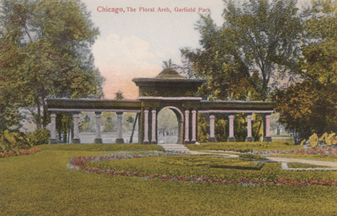
The West Side is of historical and cultural significance to Chicago, partly due to its historic purpose as a gateway for immigrants and poorer residents to settle away from the wealthier lakeside and central business districts. Now, it is home to one of the nation's largest urban medical districts, the Illinois Medical District, as well as three of Chicago's largest parks: Humboldt Park, Garfield Park, and Douglas Park. The West Side is also home to the Cook County Jail, the largest single site jail facility in the country. Nearer the Loop and the River, the West Side's former warehouse, printing, and garment districts have recently been reimagined as foodie havens and home to high-tech corporations such as Google, Uber, and more. The West Side is also home to the United Center, where both the Chicago Blackhawks (hockey) and Chicago Bulls (basketball) play their games.
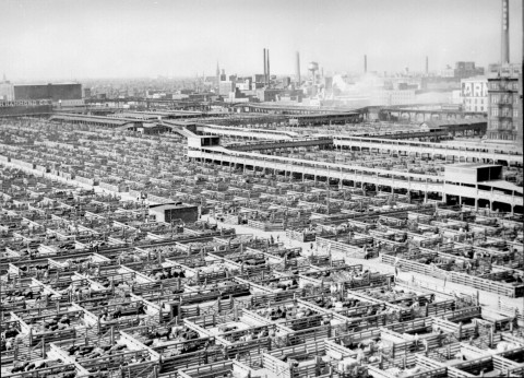
Originally, the South Side of Chicago included all the land south of the Chicago River and its branches, but over the years, it has generally been agreed upon that the Loop, which is south of the river, should be excluded from any “side" and treated as a district unto itself. After annexing the township of Hyde Park and other surrounding areas, the South Side is now larger than the North and West Sides combined. Historically, the vibrant steel and meat-packing industries attracted immigrants to the South Side (mostly from the 1840s to the end of WWI), followed by Southern Black families who came north during the Great Migration in the early twentieth century. Its richly diverse neighborhoods boast deep historic, artistic, musical, and dance traditions, as well as the Chicago White Sox (baseball) and Chicago Bears (football) teams. The South Side is where we, the University of Chicago, proudly call home; the World’s Columbian Exposition of 1893 took place in Jackson Park on the South Side; and in the near future, the Obama Presidential Center will find its home here as well.
What about the East Side? A quick glance at a map will tell you that the "East Side" of the Chicago River is...well, mostly underwater! Lake Michigan is the second-largest of the Great Lakes by volume, and one of the world's largest bodies of fresh water. But there actually is an "East Side" in Chicago -- it's one of the city's 77 community areas, located between the Calumet River and the Illinois/Indiana State Line. In fact, the community got its name because of its location east of the Calumet, and not in relation to the Chicago River. This fascinating section of the city is regularly studied by Chicago Studies, both as a destination for our annual spring Southeast Chicago History Bike Tour and as a focus of our biannual Chicago Studies Quarter: Calumet.